Showing posts with label Soil Science. Show all posts

NUTRIENT AVAILABILITY

  • Controls the availability of the essential nutrients
  • Availability of nitrogen, phosphorus, sulfur, calcium, magnesium, sodium, and molybdenum is limited under acidic conditions
The effect of soil pH on the availability of essential plant elements
Figure 4. The effect of soil pH on the availability of essential plant elements. Greater nutrient availability is indicated by thickened lines, whereas narrow lines indicate a decrease in availability.

BIOLOGICAL ACTIVITY AND PROCESSES

  • Determines the abundance of soil microorganism
  • Determines which plant species will grow
  • Low soil pH slows the biological transformation of ammonium to nitrate

PHYSICALLY

  • Indirectly, high pH can disrupt soil structure, or aggregation.

Soil acidity and liming

Soil pH is a useful indicator of the relative acidity or alkalinity of a soil. The pH scale ranges from 0 to 14, and the soil is assigned a value from the pH scale to describe the acidity or alkalinity. Since pH 7 falls midway along the scale, pH values that are equal to 7 are said to be neutral. However, pH values that fall below 7 are acidic, while pH values above 7 are alkaline.
By definition, the pH of a soil is the measurement of the concentration of hydrogen ions in soil water. Recall that the hydrogen ion is an acid cation. The greater the concentration of hydrogen ions in the soil water solution, the lower the pH. In return, the lower the pH value, the greater the acidity of the soil will be. The concentration of hydrogen ions in the soil solution is directly proportionate to and in equilibrium with the hydrogen ions retained on the soil’s cation exchange complex. Thus, the hydrogen ions retained by clay particles replenish, or buffer, the hydrogen ions in soil water.
Table 1. pH of some common items.
Item
pH
Item
pH
Most acid soils
4.0 - 6.0
Lemon juice
2.2 - 2.4
Orange juice
3.4 - 4.0
Vinegar
4.0 - 4.5
Acid rain
3.0 - 5.0
Clean rain water
5.5 - 5.7
Fresh milk
6.3 - 6.6
Blood plasma
7.2 - 7.4
Mild soap solution
8.5 - 10.0


Source: Hue, N.V. and Ikawa, I. Acid Soils in Hawaii: Problems and Management. CTAHR.
http://www.ctahr.hawaii.edu/huen/hue_soilacidity.htm

Soil pH is an important soil property, because it affects the chemical, biological, and physical processes of the soil. Thus, pH is often considered the “master variable” of soil. Its importance in nutrient management cannot be understated. To understand the significance of pH, its effects are listed below:

Typical Characteristics:

  • Formation: Mollisols form by the accumulation of calcium-rich organic matter. In the Midwestern United States, these soils formed in the dense root system of prairie grasses.
  • Physical Traits: The surface horizon of Mollisols is deep and rich in calcium, magnesium, and organic matter. The soil is often dark in color and has a soft texture. The CEC of these soils is more than 50% saturated with calcium, magnesium, nitrate, and magnesium. These soils can contain swelling clays that have poor drainage.
  • Productivity: Mollisols are naturally highly productive soils.

Moderately Weathered, Fertile Soils of Maui:

Millisols of Maui
enlarge the map

MINIMAL MOIST/DRY FERTILE SOILS (HAPLUSTOLLS)

  • Ewa Series
  • Iao Series
  • Kamaole Series
  • Kaupo Series
  • Keawakapu
  • Paia Series
  • Pulehu Series
  • Wahikuli Series
  • Waiakoa Series
  • Wailuku Series
  • Wainee Series

Unique Characteristics of Maui County Mollisols:

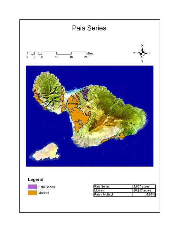
There are many soil series that fall into the order of Mollisols on Maui. The Paia Series is one series that has agricultural importance.
Paia Series
enlarge the map
  • Location: The Paia eries is located in the isthmus of Maui, among which the majority of the island’s Mollisols moderately-weathered, fertile soils are located. The Paia Series comprises of 5,600 acres in the uplands, with elevations ranging between sea level and 1,000 ft.
  • Texture: Silty clay
  • Rainfall and Temperature: The average annual rainfall is between 25 and 40 inches, and the average annual temperature is approximately 73 degrees F.
  • Slope: Gentle to moderate
  • Parent Material: The Paia Series formed from weathered basic igneous rock, and some volcanic ash.
  • Depth: Surface layer is very deep and extends 19 inches. Subsoil is 41 inches in depth.
  • Physical Traits: The soil is well-drained with slow to medium runoff and moderate permeability.
  • Color of Surface Horizon: Dark reddish brown
  • Fertility: The Paia Series is naturally high in plant nutrients, such as calcium.
  • Acidity: mildly alkaline
  • Natural Vegetation<: ilima, kiawe, lantana, among others.
  • Agricultural Use: Irrigated sugarcane.

HIGHLY WEATHERED VOLCANIC SOIL

Kula Series
   Photo by Tai McClellan
The Hana Series is a characteristic highly weathered, infertile volcanic soil.
  • Location: The Hana Series is located on the windward side of East Maui, and it occupies a land area of approximately 8,000 acres. The elevation at which you will find this soil is between sea level and in the uplands of 1,200 ft.
  • Texture: Silty clay loam
  • Rainfall and Temperature: The average annual rainfall is between 80 and 150 inches, and the average temperature is 73 degrees F.
  • Slope: Gently to moderately steep
  • Parent Material: The Hana Series was derived from volcanic ash that was deposited over cinders and `a`a lava flows. The depth of the soil profile may extend from 27 to 40 inches.
  • Depth: While the surface soil is typically 12 inches, the subsoil extends 22 inches.
  • Physical Traits: The surface may be very rocky depending upon the location. The soil has good drainage, with moderately rapid permeability and medium runoff.
  • Color of surface horizon: Dark brown/dark grayish brown
  • Fertility: The Hana Series is typically deficient in nutrients such as phosphorus.
  • Acidity: Strongly to medium acidity
  • Natural vegetation: Grasses and tree species.
  • Agriculture: Pasture.
  • Related Soil Series: Honomanu Series

HIGHLY WEATHERED VOLCANIC SOIL VS. MODERATELY WEATHERED VOLCANIC SOIL

The major differences between a highly weathered soil, such as the Honomanu Series (Hana’s sister series) and a moderately weathered soil, such as the Kula Series is highlighted in the following table. The Honomanu Series is acidic and depleted in plant nutrients such as calcium, whereas the Kula Series is slightly acidic and rich in calcium

Poorly Developed Soils (Inceptisol)

Typical Characteristics of Inceptisol:

  • Formation: Unlike mature soils, these soils lack a well-developed soil profile and are just beginning to develop a B subsurface horizon.
  • Productivity: The natural productivity of young soils vary from place to place.

Poorly Developed Soils of Maui:

Inceptisols of Maui
enlarge the map

SEMIARID, ACIDIC POORLY DEVELOPED SOILS WITH LOW BASE SATURATION (DYSTRUSTEPTS)

  • Haliimaile Series
  • Kahana Series
  • Makaalae Series

WATER SATURATED, POORLY DEVELOPED SOIL (PETRAQUEPT)

  • Amalu Series

Unique Characteristics of Poorly Developed Soils of Maui County:

The Kahana Series is the most agriculturally important of the poorly developed soils on Maui.
Kahana Series
enlarge the map
  • Location: The Kahana series is located in the uplands of West Maui, at elevations between 100 and 1,200 ft. The Kahana Series occupies approximately 2,700 acres of land.
  • Texture: Silty clay
  • Rainfall and Temperature: The average annual precipitation is between 30 and 45 inches, and the average annual temperature is 73 degrees F.
  • Slope: Gentle to moderate
  • Parent Material: The parent material of the Kahana Series is basic igneous rock, which was weathered in place.
  • Color of Surface Horizon: Dark reddish brown
  • Fertility: While Kahana soils may require irrigation, liming, and nutrient additions, it is generally very suitable for crop production.
  • Natural Vegetation: guava, koa haole, lantana, and other trees.
  • Agriculture Use: pineapple and irrigated sugarcane production, with some use as pastureland.
  • Related Soils: Haliimaile and Makaalae Series.

Origins of acidity

There are a multiple origins of soil acidity. The following is a list of causes which are common in Hawaii:
  • Release of hydrogen atoms under natural chemical processes in the soil
    • Atmospheric carbon dioxide reacts with water to form carbonic acid
    • Organic molecules react with water and cause acid dissociation
    • Oxidation of ammonium nitrogen, sulfur, and iron
  • Accumulation of organic matter and subsequent release of fulvic and humic acid, products of decomposition
  • Reaction of aluminum cations with water (a process known as hydrolysis)
  • Natural Deposition
    • Lightning deposits acidic HNO3
    • Volcanic activity deposits acidic H2SO4
  • Human Factors
    • Oxidation of applied synthetic ammonium based fertilizers
    • Oxidation of nitrogen compounds in applied animal manures and/or sewage sludge
    • Deposition of acid rain (HNO3 and H2SO4) caused by industrial pollution

Pools of Soil Acidity

There are three general pools, or sources, of acidity: active, exchangeable or residual.
    Image result for soil
  • Active acidity is the quantity of hydrogen ions that are present in the soil water solution. The active pool of hydrogen ions is in equilibrium with the exchangeable hydrogen ions that are held on the soil’s cation exchange complex. This pool most readily affects plant growth. Active acidity may be directly determined using a pH meter, such as an electron probe.
  • The second pool, exchangeable acidity, refers to the amount of acid cations, aluminum and hydrogen, occupied on the CEC. When the CEC of a soil is high but has a low base saturation, the soil becomes more resistant to pH changes. As a result, it will require larger additions of lime to neutralize the acidity. The soil is then buffered against pH change. (See base saturation discussion.)
  • Residual acidity comprises of all bound aluminum and hydrogen in soil minerals. Out of all pools, residual acidity is least available.

Highly Weathered Tropical Soils (Oxisol)

Typical Characteristics

  • Climate: Oxisols are the most highly weathered soil order. These soils form under year-round hot, tropical climates. Although climatic pattern may have changed over the course of the soil’s history, these soils formed under moist climates.
  • Mineralogy: While the subsurface soil layers contain clay particles, the layer is loaded with hydrous oxides of aluminum and iron. Hydrous oxides are the products of intense weathering of minerals, after much of the silica has leached away from silicate minerals, such as kaolinite.
  • Physical Traits: Highly weathered soils generally resist compaction and allow water to move and drain freely.
  • Productivity: Although these soils generally contain low activity clays, highly weathered, tropical soils are nonsticky and workable. Oxisols form strong aggregates, do not have a shrink and swell potential, and are resistant to erosion. However, nutrient cations, such as calcium, magnesium, nitrate, and potassium, must be added to the soil. Phosphorus may also be limited, because it tends to form strong bonds with the oxides. Organic matter can be added to increase the availability of phosphorus.

Highly Weathered Tropical Soils of Maui

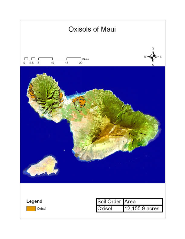
Oxisols of Maui
enlarge the map

MOIST/DRY HIGHLY WEATHERED SOILS WITH HIGH BASE SATURATION (EUTRUSTOX)

  • Lahaina Series
  • Molokai Series

Unique Characteristics of Oxisols of Maui County

The highly weathered, tropical soils of Maui are unusual, because they are located in drier regions of Maui. Nevertheless, these highly weathered soils formed under much wetter conditions. A representative Oxisol on Maui is the Lahaina Series.
Lahaina Series
enlarge the map
  • Location: The Laihaina series, located in the intermediate uplands of West Maui, occupies 21,000 acres with elevations ranging from 10 to 1,500 ft.
  • Texture: Silty clay
  • Rainfall and Temperature: The average annual rainfall falls between 20 and 35 inches, with average temperatures of 73 degrees F.
  • Slope: Nearly level to steep
  • Parent Material: The Lahaina Series soil formed in place from basic igneous rock with alluvial deposits. May contain fragments of coral, sand, and gravel.
  • Depth: Surface layer extends 15 inches. Subsoil is approximately 45 inches.
  • Physical Traits: The Lahaina series has slow to rapid runoff, moderate permeacility, and good drainage.
  • Color of Surface Horizon: Dark reddish brown
  • Fertility: Unlike many of the world’s other Oxisols, the Lahaina Series can sufficiently supply plant nutrients. It is quite workable, though irrigation is required.
  • Acidity: Medium acidity
  • Natural vegetation Cactus, kiawe, lantana, and koa haole.
  • Agricultural Use: Pineapple and irrigated sugarcane

The relative nutrient status of a plant may be easily described using the following terms:Image result for soil
Deficiency range
Nutrient deficiencies occur in plants when an essential element is not taken up by the plant in sufficient amounts. As a result, yield will be limited by the element which is deficient. While slight to moderate deficiencies do not always result in visual deficiency symptoms, distinct visual symptoms appear in severe cases.
Critical range
Below the critical range of nutrients, an addition of the essential element will trigger an increase in yield. Above the critical range, the levels of essential nutrients are considered sufficient.
Sufficiency range
Within this range, additions of the essential nutrient will not result in any increase in yield. However, uptake of the nutrient may continue. Thus, the concentration of that essential nutrient in plant tissue will also increase. We refer to the uptake of an essential nutrient within the sufficiency range as luxury consumption.
Toxicity rangeToxicities occur when an essential (or nonessential) element is taken up in great enough quantities to actually reduce plant growth. As a result, toxicities can severely limit yield.

Nutrient Mobility

WITHIN PLANT

An important characteristic of some nutrients is the ability to move within the plant tissue. In general, when certain nutrients are deficient in the plant tissue, that nutrient is able translocate from older leaves to younger leaves where that nutrient is needed for growth. Nutrients with this ability are said to be mobile nutrients, and include nitrogen, phosphorus, potassiummagnesium, and molybdenum. In contrast, immobile nutrients do not have the ability to translocate from old to new growth. Immobile nutrients include calcium, sulfur, boron, copper, iron, manganese, and zinc.
Nutrient mobility, or immobility, provides us with special clues when diagnosing deficiency symptoms. If the deficiency symptom appears first in the old growth, we know that the deficient nutrient is mobile. On the other hand, if the symptom appears in new growth, the deficient nutrient is immobile.

WITHIN THE SOIL

Mobility of a nutrient within the soil is closely related to the chemical properties of the soil, such as CEC and AEC, as well as the soil conditions, such as moisture. When there is sufficient moisture in the soil for leaching to occur, the percolating water can carry dissolved nutrients which will be subsequently lost from the soil profile. The nutrients which are easily leached are usually those nutrients that are less strongly held by soil particles. For instance, in a soil with a high CEC and low AEC, nitrate (an anion) will leach much more readily than calcium (a cation). Additionally, in such a soil, potassium (a monovalent cation) will leach more readily than calcium (divalent cation) since calcium is more strongly held to the soil particles than potassium.
Silica from minerals also dissolves and leaches from the soil profile during the processes of weathering. It is this dissolution and leaching that transforms primary minerals to the more weathered, secondary minerals that make up the finely-textured soils of Maui.

Image result for soilThe quantity of aluminum and hydrogen in each of the 3 pools of acidity is not permanently fixed. Instead, the relative amounts of aluminum and hydrogen can change, as aluminum and hydrogen moves from pool to pool. Thus, the soil is said to have a buffering capacity. Buffering capacity is the ability of the soil to resist change. In the case of acidity, it is the ability of the soil to resist change in pH. Thus, aluminum and hydrogen of one pool will replenish the aluminum and hydrogen of another pool as these acid cations are removed.
For example, as aluminum and hydrogen are removed from soil solution, the acid cations of the CEC replenish the soil solution. Likewise, minerals containing aluminum and hydrogen dissolve and release these cations as they are removed from the exchangeable pool.

OUTLINE OF BUFFERING REACTIONS:

  • Exchangeable acidity will buffer changes in active acidity
  • Residual acidity will buffer changes in exchangeable and active acidity
Each soil has a unique buffering capacity. As a rule of thumb, finely-textured clay soils tend to have greater buffering capacities than coarse-textured soils.

Rule of Thumb

  • Finely-textured clay soils tend to have greater buffering capacities than coarse-textured soils
Recall that 90% of Hawaii’s soils fall into this category. As a result, most Hawaii soils largely buffer soil acidity. This has great implications onnutrient management since buffering capacity determines the amount of resources, such as lime, that must be added to correct soil acidity. Soils that have high buffering capacities require larger amounts of liming resources to raise the pH to a target value than soils with low buffering capacities.

The increasing abundance of greenhouse gases in the atmosphere has the following three main effects:
(i) CO2 fertilisation effect on plants
(ii) Global warming and
(iii) Depletion of ozone (O3) layer in the stratosphere.
Carbon dioxide (CO2) Fertilisation Effect on Plants:
The data produced in USA have shown that atmospheric carbon-dioxide concentration has been rapidly rising since 1959 as shown in the graph. If such rising trend continues, by the end of twenty first century the atmospheric concentration of CO2 shall increase to a level between 540 and 970 ppm.
Increase in CO2 concentration in atmosphere from1959 to 2001
When the CO2, concentration of the atmosphere is more or less doubled, the growth of many plants i.e., C3, plants in particular, under favourable conditions of water, nutrients, light and temperature, could increase by about thirty per cent on average, in the short term of few years or so.
The response of plants to elevated concentrations of CO2, is called carbon dioxide fertilisation effect.
Due to increased carbon-dioxide concentration, the rate of photosynthesis also increases, and the stomatal conductance decreases due to partial closure of stomata. Hence, the transpiration rate reduces, and water-use efficiency increases.
Such effect allows many species to grow successfully in regions of water scarcity.
Under higher atmospheric carbon dioxide concentrations, plants allocate, a greater proportion of photosynthate to roots. However, greater root production increases development of mycorrhiza and fixation of nitrogen in root nodules, thus, makes possible the plants to grow in soils which are poor in nutrition.
However, in natural conditions the beneficial effects of increased carbon dioxide may not be there because of negative effects of global warming.

Typical Characteristics:

  • Parent Material: Volcanic soils, also known as Andisols, are formed from volcanic ash and cinder deposits. While most of the world’s volcanic soils are not highly weathered, there are notable exceptions on Maui.
  • Mineralogy: Volcanic soils largely consist of non-crystalline (amorphous) minerals, such as allophone and imogolite.
    • These minerals form strong bonds with organic matter. As a result, organic matter generally accumulates in the surface horizon.
    • In addition to organic matter, volcanic soils may also contain high amounts of volcanic glass material with the possibility of amorphous iron and aluminum minerals.
  • Physical Traits: Andisols are usually light and fluffy and are easily tilled. Like a sponge, these soils also hold a lot of water.
  • Fertility: When not highly weathered, volcanic soils are typically very fertile soils. However, volcanic soils form strong complexes with phosphorus. When poorly managed, phosphorus can be limiting. Additionally, the amorphous minerals that dominate volcanic soil can generate an anion exchange capacity (AEC) when under acidic conditions and depleted in organic matter. Fertility problems may be corrected with additions of organic matter, lime and/or fertilizer amendments.

Volcanic soils of Maui:

Maui Andisols
enlarge the map

GLASSY, DRY VOLCANIC ASH SOIL (VITRITORRAND)

  • Alae Series
  • Oanapuka Series

HOT, DRY VOLCANIC ASH SOIL (HAPLOTORRAND)

  • Makena series

MOIST/DRY VOLCANIC ASH SOIL (HAPLUSTAND)

  • Io Series
  • Kaipoipoi Series
  • Kula Series
  • Laumaia Series
  • Oli Series
  • Olinda Series
  • Pane Series
  • Puu Pa Series
  • Ulupalakua Series

VOLCANIC ASH SOIL WITH VERY HIGH WATER RETENTION (HYDRUDAND)

  • Hana Series
  • Kailua Series
  • Honomanu Series

Unique Characteristics of Volcanic Ash Soils of Maui County:

Although there are several different types of volcanic soils on Maui, we will discuss two soils that are agriculturally significant.
  • Moderately weathered volcanic ash soil
  • Highly weathered volcanic ash soil.
Kula Series and Hana Series
enlarge the map
Moderately weathered volcanic soil

Image result for soil

Land managers can manage soil acidity by raising the pH to a desired value through several methods:
  • Flooding: In lowlands systems, flooding may be an effective technique in raising the pH of the soil. However, this effect is only good for the time for which the soil is flooded. Flooded or paddy mineral soils are ‘self-liming’. When they are flooded and become anaerobic (lack of oxygen in the soil atmosphere) for a period of time, the pH rises toward neutrality even when the soil pH was originally acidic. If the soil is subsequently drained and becomes more aerobic (more oxygen in the soil atmosphere), the pH will return to an acidic state
    • However, care must be taken if the soil contains manganese-oxide minerals, since flooding conditions may lead to manganese toxicity.
    • Crop consideration is also required. Flooding conditions reduces the oxygen within the soil, which is needed for plant life. As a result, crops that do not tolerate high amounts of water and low oxygen levels are not be suited for flooded conditions. Taro and rice are examples of crops that grow well in flooded lowlands.
  • Additions of organic matter: Additions of organic matter is a viable option to manage problems associated with soil acidity.
    • Organic matter increases the cation exchange capacity of the soil. As the base saturation increases, the relative amount of “acid cations” decreases.
    • In addition, organic matter forms strong bonds, known as “chelates,” with aluminum. Chelation reduces the solubility of aluminum and soil acidity. Again, if your soil is prone to manganese toxicity, it is not suggested that you add organic matter.
  • Additions of wood ash: Like organic mater, wood ash increases base saturation and forms chelates with aluminum.
  • Conventional Liming: Various liming materials may be added to the soil that neutralize, or counteract, soil acidity. Liming materials are bases that react with hydrogen ions in the soil solution to form water?
    • Examples of common liming materials are limestone (calcium carbonate), dolomite (calcium/magnesium carbonate), hydrated lime (calcium hydroxide), and quicklime (calcium oxide). Calcium and magnesium silicates are also used as liming agents.

ALUMINUM TOXICITY

Aluminum toxicity can occur in soils that have large amounts of aluminum containing minerals. In such soils, aluminum can dissolve into the soil solution as the soil pH drops below 5.4. In contrast, aluminum solubility decreases dramatically as the soil pH increases above 5.4. As a result, proper management of soil pH can prevent problems associated with aluminum toxicity.
  • Excessive amounts of aluminum can inhibit root development and limit crop growth.
  • Aluminum saturation is an expression which describes the relative abundance of aluminum in the soil.
    • Like base saturation, aluminum saturation is the percentage of the CEC occupies by aluminum. Like all cations, aluminum held by the cation exchange complex is in equilibrium with aluminum in the soil solution.
    • Although the tolerance to aluminum varies among plant species, most plants do not tolerate greater than 15% aluminum saturation.
    • However, certain crops grown in Hawaii, such as sugarcane, pineapple, corn and ti, can tolerant relatively high levels of aluminum saturation.

Conditions that cause aluminum toxicity

Aluminum toxicity occurs readily under acidic conditions, especially when pH values are equal to or less than 5.4. In the acidic soils of the tropics, aluminum toxicity may become a serious problem and limit crop yield. Management of soil pH is the key factor in avoiding aluminum toxicities. Aluminum toxicity may be ameliorated by liming your fields.

a. Surveying is a process which determines positions of points on the surface of earth, in horizontal distance.
Objective: to prepare a plan or map
Uses:
(1) To prepare road
(2) To make irrigation channel
(3) To make channels
(4) To make railway lines
(5) In soil conservation etc.
b. Soil Surveying helps in getting and collecting information’s about soils and preparing an inventory of soil resources of an area.
c. Types of surveying:
1. Reconnaissance soil survey (RSS): helps to identify benchmark soils for delineating problem and potential areas and providing information’s useful for making land use plants and agriculture development.
Scale: 1:50,000 -> 1cm = 0.5km (for state and district level survey)
1:2, 50,000 1cm = 2.5km (for national survey)
2. Detailed soil survey (DSS): helps to understand the soil and land problems and for different conservation measures to control soil erosion, to fix irrigation scheduled, in agriculture and watershed development.
Scale: 1:8,000 1cm = 80mm or 0.08km
1:20,0001cm = 0.2km
1:10,000 for Arial photos
a. Cadastral survey (land survey): determines land boundaries and areas.
b. Topographic survey: determines the shape or relief of the ground and the location of various natural and artificial features.
f. Instruments used in Surveying:
A. Instruments Used for Measuring Distance:
1. Chain: The chain is composed of 100 or 150 pieces of galvanized mild steel wire 4mm in diameter called links.
a. Metric chains: The chains are made in lengths of 20 and 30 meters.
b. Giinter’s Chain: It is 66 fit long and is divided into 100 links. Each link is 0.66 ft. long.
c. Revenue Chain: It is 33 ft. long and divided into 16 links. Each link is 2.0625 ft. long. It is commonly used for measuring fields in cadastral survey.
d. Engineer’s chain: It is 100 ft. long and it is divided into 100 links. Each link is 1 ft. in a length. Used in all Engineering surveys.
2. Arrows (chain pins): also called as marking or chaining pins and are used to mark the end of chain during the process of chaining. The arrows are made 400 mm in length. They are pointed at one end of inserting in to the ground.
3. Tape: Metric, cloth and steel tape.
B. Instruments for marking stations:
1. Wooden Pegs: These are used to mark the positions.
2. Ranging rods: Used for making the positions of stations and for ranging.
3. Ranging Poles: Used in the case of very long lines.
4. Offset Rod: It is used for aligning short offsets.
5. Plumb Bob: It is also used for testing the verticality of ranging poles.
g. Contour line: an imaginary line of constant elevation on the surface of the ground.
h. Contour interval: the vertical distance between two consecutive contours.
i. Theodolite is a device used for measuring horizontal and vertical angles.
j. Hydrology is the earth science dealing with the occurrence and movement of water upon and beneath the land areas of globe.
k. The average & annual rainfall of India is about 119.4 cm.
l. Gross Command Area (G.C. A): total area which can be irrigated by a certain channel or a project.
m. Culturable Command Area (C.C. A): it is the portion of the G.C. A which is Culturable or cultivable.
n. C.C. A. = G.C.A. – uncultivable area in the G.C. A.
o. The common practice in northern India for distribution of water through canal to farmer is Warabandi (numbers of turns).
p. Aquifer: A porous soil or geological formation which will yield significant quantity of water.
q. Unconfined aquifer is also known as a free, phreatic or non-artesian aquifer, is one overlying an impervious stratum, in which the water is not under pressure.
r. Confined aquifers: also known as artesian or pressure aquifers lie below an impervious layer and the water in them is under pressure.
s. Manually operated water lifting devices: Swing basket (lift – 1 to 1.2m), Counter poise lift (2-3 m), don (1.2m), Archimedean screw (lift 0.5-1.2 m). Paddle wheel (lift <1.2 m).
t. Animal powered operated water lifting devices: Rope and bucket lift (15m), Persian wheel (lift <10 111), Chain pump (lift<6 m).
Types of pumps for Irrigation:
1. Displacement pumps (reciprocating pumps and rotary pump): operating pressure (atm pressure i.e. 1 kg/cm^ water lift <10m, best result-7mi
2. Centrifugal pump (suction Iift<4.5m, Maximum suction head is taken as 6 m, but beyond about 4 m the efficiency of pump drop down substantially.). Impeller and casing are two parts of centrifugal pumps.
3. Turbine pumps (Deep well turbine pumps and submersible pump) – suction lift >7.5 meters.
4. Propeller pumps (axial flow and mixed flow) -Suction lift 1-2.5 meters.
5. Airlift pumps
6. Jet pump (suction lift 12-18m)
a) The interrelationship of capacity, head, power and efficiency – are best shown graphically and these curves are called the “characteristics of the pumps”.
b) Priming is the process of removing air from pump casing and suction pipe by filling water in the suction pipe.
c) Static bead = Static suction head + Static discharge head
d) Total head = Static head + Friction head + Velocity head
e) Water is measured under two conditions: at rest and in motion. Hence, the s commonly used in measuring water is in unit flow and unit of volume.
f) The commonly used units of water at rest are the litre, cubic meter and hectare- centimeter.
g) The commonly used units of water in motion are in m3/s and It/s.
h) Orifices, Weirs, Notches and Parshall flumes are used to measure the rates of flow (discharge) of water.
i) The basic formula for calculating the discharge through a weirs is Q = CLHm
Where, C = a coefficient, depending on the nature of the crest and approach conditions
L = length of crest cm,
H = head of the crest cm,
m = exponent depends on the type weir opening
j). Types of weir based on their shape:
1. Rectangular weir
(a) Suppressed Rectangular Weir (Francis formula)- Q = 0.0184LH-”^2
(b) Contracted Rectangular Weir Q = 0.0184(L-0.1nH) H^/^ zvhere, n= numbers of end contractions
2. Cipolletti weir – trapezoidal weir (slope H: V=l:4) Q=0.0186LH 3/2
3. 90″V notch weir (triangular shape) Q = 0.0138 H’-‘^
k) Bernoulli’s theorem is application of the law of conservation of energy to fluid flow.
l) Total energy (head) = Pressure energy (head) + Velocity energy (head) + Elevation head energy
m) Darcy’s law is applicable to groundwater flow and drainage problems,
clip_image018
n). Hydraulic radius is ratio between the cross-section (a) of the stream and its wetted perimeter (p).
o). Soil texture refers to the relative proportion of the various size groups of mineral particles in a given.
p). Soil structure refers to the manner in which the soil particles are arranged in groups or aggregates.
q). A typical Si.t loam soil contains about 50% solids, 30% water and 20% air.
r). Clay soils contain more than 40% of clay particles and 45% sand or silt.
s). Hygroscopic water: water held tightly to the surface of soil particles by adsorption forces.
t). Capillary water: water held by forces of surface tension in continuous films around soil particles and capillary space.
u). Gravitational water: water that moves freely in response to gravity and drains out of the soil.
v). Percolation is the downward movement of water through the soil profile.
w). Seepage is the lateral movements of water from water sources such as a reservoir or irrigation canal.
x).Tensiometers, electrical resistance measuring devices and neutron moisture meter are used for measurement of soil moisture.
y). Evaporation is the process of vaporization by which water is transferred into the atmosphere.
z). Transpiration is the discharged of water as vapour into the atmosphere by the leaves and stems of living plants.
Irrigation efficiency is the ratio usually expressed as per cent, of the volume of the irrigation water transpired by plants, plus that evaporated from the soil, plus that necessary to regulate the salt concentration in the soil solution, and that used by the plant tissue to the volume of water diverted, stored, or pumped for irrigation

Movement of nutrient from soil to rootImage result for soil

There are three basic methods in which nutrients make contact with the root surface for plant uptake. They are root interception, mass flow, and diffusion.
  • Root interception: Root interception occurs when a nutrient comes into physical contact with the root surface. As a general rule, the occurrence of root interception increases as the root surface area and mass increases, thus enabling the plant to explore a greater amount of soil. Root interception may be enhanced by mycorrhizal fungi, which colonize roots and increases root exploration into the soil. Root interception is responsible for an appreciable amount of calcium uptake, and some amounts of magnesium, zinc andmanganese.
  • Mass flow: Mass flow occurs when nutrients are transported to the surface of roots by the movement of water in the soil (i.e. percolation, transpiration, or evaporation). The rate of water flow governs the amount of nutrients that are transported to the root surface. Therefore, mass flow decreases are soil water decreases. Most of the nitrogen, calcium, magnesium, sulfur, copper, boron, manganese and molybdenum move to the root by mass flow.
  • Diffusion: Diffusion is the movement of a particular nutrient along a concentration gradient. When there is a difference in concentration of a particular nutrient within the soil solution, the nutrient will move from an area of higher concentration to an area of lower concentration. You may have observed the phenomenon of diffusion when adding sugar to water. As the sugar dissolves, it moves through parts of the water with lower sugar concentration until it is evenly distributed, or uniformly concentrated. Diffusion delivers appreciable amounts of phosphorus, potassium, zinc, and iron to the root surface. Diffusion is a relatively slow process compared to the mass flow of nutrients with water movement toward the root.

Organic matter

Most soil organic matter accumulates within the surface layer of the soil. This organic matter may be divided into two groups: non-humic matter and humic matter.
Non-humic matter includes all undecomposed organic material within the soil. Examples of non-humic matter are twigs, roots, and living organisms.
Humic matter includes humic acids, fulvic acids, and humin. (Humin is the dark material in soil that is highly resistant to decomposition.)

IMPORTANCE OF SOIL ORGANIC MATTER

  • Due to its tremendous surface area, soil organic matter:
    • Acts like a sponge to store water
    • Retains and provides nutrients (CEC)
    • Glues and binds soil particles into stable aggregates
  • Reduces the occurrence of aluminum toxicities.
Like low activity clays, organic matter may have either CEC or AEC, depending upon soil pH. However, it will rarely have AEC. In fact, the pH must fall to approximately 2.0 before it will have AEC.

CATION EXCHANGE CAPACITY OR ANION EXCHANGE CAPACITY?

  • Soil organic matter may have both AEC and CEC. However, the charges on organic matter are dependent upon soil pH. For soil organic matter to generate an AEC, the soil pH must be 2.0.

MANAGEMENT

Without additions of organic matter, tillage practices will greatly reduce organic matter content in the soil. And so, no-till and minimum tillage systems with the return of organic matter to the soil are gaining favor by farmers to improve and conserve soil quality.

CEC and surface area of common soil minerals
MineralTypeCEC (surface charge cmolc/kg-1)Surface area (external m2/g-1)
SmectiteHigh activity clay-80 to -15080 to 150
VermiculiteHigh Activity clay-100 to -20070 to 120
Fine MicaHigh activity clay-10 to -4070 to 175
ChloriteHigh activity clay-10 to -4070 to 100
KaoliniteLow activity clay-1 to -155 to 30
GibbsiteAl-oxide+10* to -580 to 200
GoethiteFe-oxide+20 to -5100 to 300
AllophaneAmorphous+10 to -150100 to 1000
HumusOrganic-100 to -500Variable
* Positive sign indicates that the minerals no longer exhibit a cation exchange capacity, but rather an anion exchange capacity.
Adapted from Table 8.1, Brady and Weil (2002).

Image result for soil
ElementAbbreviationForm absorbed
NitrogenNNH4+ (ammonium) and NO3- (nitrate)
PhosphorusPH2PO4- and HPO4-2 (orthophosphate)
PotassiumKK+
SulfurSSO4-2(sulfate)
CalciumCaCa+2
MagnesiumMgMg+2
IronFeFe+2 (ferrous) and Fe+3 (ferric)
ZincZnZn+2
ManganeseMnMn+2
MolybdenumMoMoO4-2 (molybdate)
CopperCuCu+2
BoronBH3BO3 (boric acid) and H2BO3- (borate)

Powered by Blogger.

Visitors

Print Friendly Version of this pagePrint Get a PDF version of this webpagePDF


 download University Notes apps for android

Popular Posts

Flag Counter